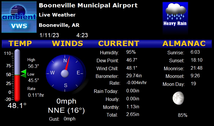
|
|
|
|
|
Welcome
to Booneville, AR. Town center is the intersection of State
Highways 10 and 23. The airport (4M2) is three miles east of
town on highway 10. RV travelers,
click here for information on
the Booneville Municipal RV Park. |
Distance calculator to 4M2 plus the AirNav airport listing
|
|
|
4M2 Staging
Point for Water Bombers |
|

by
Mike Wyrick
On February 9, 1870, an Act of Congress was
passed and signed by President Ulysses S. Grant directing the
Secretary of War to take meteorological observations and give
warnings of the approach of storms. This was the birth of the
National Weather Service.
July 2012, the NWS recorded the hottest July on record in the US
and the driest since the
Dust Bowl of the 1930s. The Dust Bowl era got its name after
Black Sunday, April 14, 1935, and lasted from 1932 to 1940.
On July 24, 2012, for the third time during the month, Forest
Service water bombers used the airport as a staging area to load
water and fly to the fire scenes in the area. Though smoke could
be seen from anywhere in the city of Booneville, thanks to
extraordinary efforts by both airborne and ground base fire
fighters, no harm to people and only minimal damage to
structures were reported. |
|
|
|